Otel RezervasyonUçuş Yer AyırtmaHava Raporları
|
|
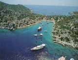
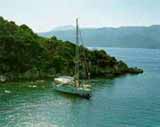
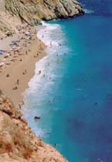
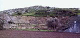
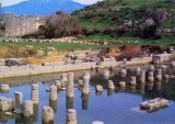
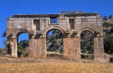
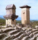
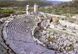
Kas was originally called Habesos or Habesa in the ancient tongue of Lycia and later was given the name Antiphellos. It is one of the oldest settlements in the region of Lycia. Most of the ancient settlement is now covered by the modern town of Kas. The rock-cut tombs to the north-east of the town date to the 4th century B.C. On a rise between the open sea and the hill, which was probably the acropolis of the ancient city, lies a rock tomb formed like a Doric structure with Doric triglyphs on the facade. Inside the tomb is to be found a frieze of dancing female figures. The acropolis was surrounded by a fortified wall, of which traces are to be seen on the facade facing the island of Meis (Kastellorizon). No traces of fortifications are to be seen on the northern or western slopes. To the west of the modern town stands the ancient theater overlooking the sea. This structure possesses a remarkable view. It was constructed of local limestone and today the tribunes and outer walls are still visible although no trace of the skene is left. On the western edge of the acropolis are traces of a temple. Tombs of the Roman period are scattered about the town and along the coast. PATARA There are a number of stories connected with the founding of Patara, one of Lycia's principal harbours. Some ancient sources relate the legend that, the city was established by Patarus, the son of Apollo and Lycia, a nymph of the river Xanthos. Strabo describes the city as a large port, also explaining that it was founded by Patarus. In reality, however, Lycians founded the city, and its name, as seen on inscriptions and coins, was Patar in the Lycian language. Patara derived its fame in ancient times from the oracle of Apollo situated there. Oracles in the temple, which was kept open only during the winter months, sought answers to questions concerning the future. Patara, which passed into the hands of Alexander the Great in 334 B.C., retained its importance as a commercial centre and naval base throughout the Hellenistic period. In the course of Egyptian domination, Ptolemaios II (reigned 285-246 B.C) changed the city's name to Arsinoe in honour of his wife. Apparently however, the name did not catch on, and before long its original name was again in use. Another interesting event in Patara's historical record occurred in the year 42 B.C. during Brutus' seige of the city following his capture of Xanthos. By surrounding Patara, Brutus, holding up the tragic end of Xanthos as an example, hoped the Patarans would surrender without bloodshed. When his proposal was turned down, Brutus began to auction to the Patarans as slaves, people he had captured from neighbouring Xanthos, whose citizens were related to the Patarans. When this initiative also failed to produce results, he put his forces into action the next morning. When the Patarans grasped the seriousness of their situation they sent word of their surrender. Brutus killed no one after entering the city, but wanted the people to turn their valuable possessions over to him. They obeyed. Then a slave informed Brutus that his master had hidden gold. In the trial the slave's owner said nothing, but his mother, in tears, announced that her son was innocent, that it was she who had concealed the gold. Even though the slave objected to the woman's testimony, Brutus must have been moved by the silence of the young man and the suffering of his mother, for he let them go free and punished the slave for informing against his master. Under Roman domination, Patara again became one of Lycia's leading ports and received the title of metropolis. The Roman provincial governor resided in Patara and the official archives of the region were kept here as well. During this period, St. Paul passed through Patara on his way to Rome (60 A.D). It is also known that the Emperor Hadrian, along with his wife, stayed for a time in the city. In addition, it undoubtedly won special honour during the Christian era as the birthplace of St. Nicholas. When one enters the ruins via a stabilized road, the first monumental structure to catch the eye is the city gate. According to the inscription on it, it was erected in the name of Mettius Modestus, the Roman governor of Lycia-Pamphylia around 100 A.D., and his family. Busts of the governor and members of his family were supported by consoles on either side of the triple arched gate, which is in the form of a typical Roman triumphal arch. The remains of several buildings are visible on the side nearest the sea along the plain at the foot of the hills. Even though it is not possible to name these building with certainty, one can partly distinguish, hidden among the overgrowth, a bath and a Byzantine basilica with a nave and side aisles. The most important and best preserved structure in this area is a small temple in the Corinthian order. Measuring 13x16 metres and rising above a small podium, the Temple of Inantis is highly decorated, especially its 6 metre high cella door. It has been dated to the second century A.D. The ruins of a large bath are located to the south of the temple. From its inscripion it is apparent that the bath, dedicated to the Emperor Vespasian (reigned 69-79 A.D.) who made monetary contributions to public works in the region, was comprised of five main intercommunicating compartments, each having its own specific function. The small chambers in the eastern part of the bath made up the boiler section. Small holes visible in the stone walls of the building were made by nails that held marble-facing panels in place. On the north-east slope of the hill is a well preserved theatre. The cavea, which leans into the slope, is divided in two by a diazoma entered by two galleries on the east and west. Because the cavea and the orchestra are completely covered by sand from the sea, it is impossible to be certain about the state of the seats. On the lower floor of the two-storey stage building are the five doors standard to Roman theatre architecture. On the outer face of the stage building is a long inscription in Greek, according to which, a Pataran woman named Vilia Procula had the building constructed in 147 A.D. and dedicated it to Emperor Antoninus Pius; however, the theatre must be older than this. Similarly, another inscription mentions a priestess of Apollo in connection with certain repairs carried out during the reign of the Emperor Tiberius (reigned 14-37 A.D.) Besides a few tombs and large cistern, the hill where the theatre is located, presumed to be the acropolis, contains no other ruins worth describing. On the western side of the ancient harbour, which is now a marsh, is a granary which a Latin inscription informs us was erected in the name of the Emperor Hadrian. This enormous structure, completely intact except for the roof, contains eight long grain bins. Eight separate doors along the front of the building give entry to these storage areas. A building in the form of a temple and exhibiting excellent masonry, is situated to the north of the granary. The colonnaded facade, approached by steps on its harbour side, and the half-columns on the outer face of the one wall still standing, indicate that the building was probably a pseudoperipteral temple or a monumental tomb. ANTIPHELLOS (KAS) The ruins of Antiphellos are spread around the town of Kas, which lies at the neck of a small peninsula in the Mediterranean. Its location makes it one of the most beautiful sites on the south-west Anatolian coast. From what we can glean from Pliny, the original Lycian name of this ancient city was Habesos. Later written sources however, give the city's name as Antiphellos. It is agreed that Antiphellos was a small port linked to neighbouring Phellos, some 7-8 km. to the north as the crow flies. The term "phellos" means "rocky place" in Greek. Antiphellos means "opposite the rocky place". Because there was an increase in trade contacts from Hellenistic times onwards, Antiphellos gained special importance as a port for the export of the region's timber. Bearing in mind the difficulty of land communications and the perpetual scarcity of suitable arable land around it, it is certain that this town never became a large city. In spite of the fact that it was established in a place open to attack and difficult to defend, there is no trace of city walls on the landward side. The only extant remains of fortifications consist of rectangular walls of Hellenistic date that run the length of the shore. An ancient breakwater Iying more or less below the foundations of today's harbour has been completely destroyed. Behind the harbour, on the road to the Çukurbag peninsula, are the remains of a temple foundation. This temple, which is constructed of ashlar masonry, dates to the first century B.C. Going from the temple directly west, one comes across a lovely little theatre of Hellenistic type capable of seating approximately 3.000 people. There is no diazoma in the cavea, which is comprised of 26 tiers of wooden stage. There is an exit and an entrance to the stage on two sides. A tomb in the Doric order carved from living rock is situated north-east of the theatre. In the funerary chamber, which is entered by a high door, are three benches. That directly opposite the door is decorated with a frieze having to do with funeral rites; it depicts 25 female figures, dancing hand-in-hand. The sides of the benches are embellished with rosettes and oyster shell motifs. These features indicate a fourth century B.C. date. Other tombs in a variety of forms are found on the town's northern slopes. An important monument worth visiting because of its regional architectural characteristics, in the Lycian tomb on Uzunçarsi Caddesi, the entire length of which is now a protected historic site. This monument, which has become the symbol of Kas, is a single-doored hyposorium, which together with the thick base surmounting it, is carved from the solid rock. Above this is the sarcophagus itself, which is cut from a separate piece of stone and its lid. Two lions' heads resting on their paws are carved on each of the lid's two long sides. In addition to providing decoration the lions'heads also facilitated lifting the lid and placing it on top of the sarcophagus. Male and female figures connected with funerary observances can be made out on the narrow western face, which is divided into four panels. On the tomb's base is an eight-line Lycian inscription. The monument dates to the fourth century B.C. XANTHOS Xanthos, described by Strabo as Lycia's largest city, takes its name from the river that flows beside it, the Xanthos (today's Esen Çayi), which means "yellow" in Greek. Its oldest name, however, appeared as 'Arnna' in ancient written sources and on coinage. Homer states that one of the heroes in the Trojan War, a man named Sarpedon, came from Xanthos, However, the earliest finds discovered in French excavations of the city, in progress since 1950, date to the eighth century B.C. Xanthos maintained its independence until 545 B.C., when it was razed in the course of the Persian invasion under the command of Harpagos. In spite of their defeat, Xanthians passion for heroism and honour was immortalized in the pages of history. Herodotus describes the horror of these events and the terrible fate of the Xanthians thus: "Harpagos, marching to the Xanthos plain at the head of his forces, in spite of their small numbers, performed many honourable deeds. In the end, when they understood that they would be defeated, they retreated behind the city walls and set fire to their wives, children, slaves, and their goods, reducing all to ashes. And after this, they hurled themselves on their enemies. Except for 80 families who were not present in the city during the battle, all of the Xanthians perished." As a result of excavations, it is also known that some time between the years 475 and 470 B.C. Xanthos suffered another major calamity when its acropolis burned to the ground. After this fire the city was rebuilt, and, expanding rapidly, it soon developed into a centre which had contact with the western world. With the invasion of Alexander the Great, Xanthos undoubtedly again went through troubled times. Still another bitter chapter in this disaster-filled history was Brutus' occupation of the city in 42 B.C. during Rome's civil wars. Written sources describe these events in great detail. The Xanthians, forewarned of Brutus' attack surrounded the city with a deep trench, destroying the quarters that lay outside it so as to leave no provisions for the Romans. Brutus, while attacking the walls from one side, marched his infantry to the gates. The people, in spite of their exhaustion and the fact that nearly all of them were wounded, continued to defend the city. Then the neighbouring people of Oinoanda, in an act of treachery against the citizens of Xanthos, showed the enemy the ways by which the city could be entered. When Xanthos was on the point of being captured, the people ran to their homes and voluntarily killed their families. They speared the envoys Brutus sent to them to offer a truce and threw themselves on pyres they had made, set fire to them, and died in the flames. Excluding slaves, Brutus was able to take only a few women and 150 men. The Xanthians fought to the death against the powerful Roman armies to protect their freedom, and in doing so demonstrated their great courage one last time. Under Roman domination, whether with the contributions of Rome or of wealthy Lycians, Xanthos developed rapidly and succeeded in recreating its former brilliance. Later, during the Byzantine period, the city became the seat of a populous bishopric, but it was finally destroyed once and for all by Arab raids in the seventh century. Xanthos was first investigated in 1838 by Sir Charles Fellows, who took a large number of the works of art he had discovered back to the British Museum in London. The city's main centre was the Lycian acropolis that rises straight up from the bank of the river Xanthos (today's Esen Çayi). On its east west and south sides, the acropolis is enclosed by fifth century B.C. city walls in polygonal masonry. The northern wall dates to the Byzantine era. Xanthos' earliest remains are located in the south-east corner. One of the structures here, a building of square plan comprised of several interconnecting rooms, is thought to have been a palace destroyed in the course of Harpagos' invasion. Buildings were constructed on top of the palace ruins during the period of Persian domination, however, one can clearly see that these met with a fire. On reaching the highest point of the acropolis, one encounters a temple with a rectangular plan; only the large stone blocks of its foundation survive today. It is unfortunate that, a number of the structures like this in the acropolis suffered extensive damage, and that their building materials were subsequently reused in a variety of other places. Located immediately in front of the Byzantine walls is a second century A.D. Roman theatre that was in all probability built atop a pre-existing theatre of Hellenistic date. The tiers of seats are in a fairly good state of preservation. The orchestra, full of stones from the stage building, which is in a ruinous state, is entered from the east via a vaulted parados. The western parados serves only as a stage exit and does not open to the outside. On the west of the theatre are two famous, magnificent Lycian sepulchral monuments standing side by side. The first of these, which is 8.87 metres high and is known as the Harpy Tomb because of a relief frieze carved on it, consists of a small funerary chamber surrounded on all four sides by a massive stone pillar. This chamber is covered at the top with a stone slab. The tomb's marble reliefs were taken by Fellows to London in 1842. The reliefs now seen in their place are plaster copies cast from the originals. The subject of these reliefs, as difficult to understand as it is interesting, is the presentation of gifts by family members to the owner of the tomb and his wife. On the north and south sides, fantastic creatures called harpies-half bird, half woman-carry the souls of the dead, represented as children, toward the heavens. The monument dates to 480-470 B.C. Next to the Harpy Tomb is another tomb of a somewhat different type. This example, measuring 8.95 metres high in its entirety, dates to the fourth century B.C. It consists of a pillar made up of large stone slabs covered by a three-stepped roof, with a Lycian-style sarcophagus at the summit. The most important ruin in Xanthos is the Inscribed Obelisk, situated behind the north portico of the agora. The monument, dated 425-400 B.C., is an inscribed monolith rising atop a two-stepped krepis. From fragments found during excavations, it has been determined that this was originally a monumental tomb some 11 metres high, consisting of the existing pillar, on top of which was a burial chamber encircled, like the Harpy Tomb, by relief friezes. On top of this was a horizontal stone roof crowned by a statue of a prince seated on a lion-shaped throne. The inscription, which is on all four faces of the pillar and is more than 250 lines long, is the longest known Lycian inscription and gives important information about the period's history. According to the inscription, the monument was erected to commemorate the battles and victories of a Lycian prince named Kherei. On the descent from the acropolis, there is a beautiful Hellenistic tower and an ancient stone-paved road leading to one of the city gates from the direction of the sea. An inscription containing the name Antiochos dates the gate. An archway behind the gate is dedicated to the Emperor Vespasian (69-79 A.D.).A little further to the north we can see some stone blocks of a podium, all that remains in situ of a famous heroon in the form of an lonic temple. This building is known in archaeological literature as the Nereid Monument. Almost all of the rest of the monument, dating to c. 400 B.C., is now in the British Museum. In the Roman acropolis are the ruins of a huge monastery which has been excavated only recently. It has a large church, built in the Byzantine period on top of a Roman temple. The church's atrium and basilica are of the classical type with a nave and two side aisles. The trefoil baptistry in the north of the apse, with its marble pool and floor mosaics, is well worth seeing. Several rock-cut tombs and monuments standing side by side in the south-east corner of the acropolis present an impressive sight. This site was the location of Lycia's oldest tomb usually known as the Lion Tomb, but sometimes mentioned by the name of its owner, a certain Payava. Today, all that can be seen of the tomb in situ are its foundation walls; the upper portions of the monument are now in the British Museum. TEIMIUSSA Directly east of today's village of Üçagiz, this ancient town, in which nature and history complement each other, is one where the picturesque attains a beauty of which one can never get one's fill. Just as we have no knowledge at all of Teimussa's history, there is also no known coinage from the site. The existence of tombs bearing inscriptions in Lycian points to settlement prior to the fourth century B.C. Aside from an entry gate, a few simple foundations and some walls in the sea, all of the visible remains consist of tombs. Two rock-cut tombs in the form of houses, their doors broken, can be seen in a spot near the store. On the tomb at the right is the figure of a naked child; above the door is a Lycian inscription typical of the fourth century. Continuing directly east, one comes to a wide area covered with Lycian sarcophagi from the Roman period. It is interesting that inscriptions on some of them mention individuals from Cyaneae or Myra, and inscriptions have been found saying that people who desecrated the tombs would pay their fines to those cities. In all likelihood, Teimiussa was a small settlement tied administratively to these two cities. At the town's eastern end one descends to a small quay via steps hewn from living rock. As a result of settling of the terrain, sone of Teimiussa's ruins are now under water, a feature that gives the site added attraction. LETOON To reach Letoon, you turn west one kilometer beyond the road from KINIK to Fethiye and continue 5 km. The history of Letoon is closely linked with that of Xanthos. It is known to have been one of the most important religious centers of the Lycian region. Due to the rising water level, archeological digs have been suspended. The remains unearthed indicate they belong to the period between the 7th century B.C. and the 6th century A.D. The most important edifice is the Greek style theater which has been preserved until our day.
|