Κράτηση ΞενοδοχείουΚράτηση πτήσηςΜετεωρολογικές προγνώσεις
|
|
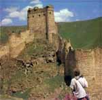
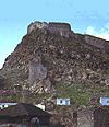
City, northeastern Turkey. Kars is situated on a plateau 5,740 feet (1,750 m) above sea level on the Kars River, a tributary of the Aras River, near the border with Armenia. The city, divided into an older upper section and a newer part to the south, stretches out on either side of the Kars River; the two sections of the city are linked by an ancient bridge built by the Seljuk Turks. The seat of an independent Armenian principality during the 9th and 10th centuries, Kars was captured by the Seljuks in the 11th century. Taken by the Mongols in the 13th century and by Timur (Tamerlane) in 1387, it was incorporated into the Ottoman Empire in 1514. After withstanding a siege by Iranians in 1731 and successfully resisting the Russians in 1807, it fell to the Russians in 1828 and 1855 and was formally annexed by Russia in 1877-78. It was returned to Turkey in 1918, though the Soviet Union later (1945-47) tried unsuccessfully to reclaim it as part of Armenia, U.S.S.R. Kars's historical buildings include Kümbet Camii ("Church of the Apostles"), an Armenian church that was converted into a mosque; a bath dating from the Ottoman period; and an old citadel overhanging the river that was once a strong military post (probably late 16th century). Kars is important as a center for trade in livestock and is also noted for its cheese. It also produces coarse woolens, carpets, and felts. An important military station, it is linked by rail and road with the principal Turkish cities. The region around Kars was part of the Armenian kingdom in antiquity and contains a number of sites dating from that period. Ani, east of Kars city and near the Armenian frontier, was the Bagratid capital in the 10th century.
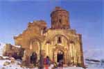
ANI Ancient city site in extreme eastern Turkey.
Ani lies east of Kars and along the Arpaçay (Akhuryan) River, which
forms the border with Armenia to the east. Situated along a major east-west caravan route, Ani first rose to prominence in the 5th century AD and had become a flourishing town by the time Ashot III the Merciful (reigned 952-977), the Bagratid king of Armenia, transferred his capital there from Kars in 961. Thus began a golden age for the city, which was beautified under two subsequent Bagratid rulers. The many churches built there during this period included some of the finest examples of medieval architecture. With a peak population of about 100,000 by the early 11th century, Ani was larger than any European city and rivaled Baghdad, Cairo, and Constantinople in its size and magnificence. It remained the chief city of Armenia until Mongol raids in the 13th century and a devastating earthquake in 1319 sent it into an irreparable decline. Eventually the site was abandoned. The handful of surviving churches and the remnants of the city walls attest to the extraordinary quality of Armenian stonework during the Middle Ages. The modern Turkish village of Ocakli is nearby. In the northeastern corner of the country, stands Kars, over a high plateau. The province, famous in Turkish history, lies at the foot of a magnificent fortress, the Kars Kalesi from the 12thcentury. This castle constructed by the Seljuks, was later restored in the 19th- century, and it affords a wonderful view of the land below. Nearby is an old cathedral which was subsequently used as a church, named as the Havariler Museum (the Church of the Apostles) where some relief of the Apostles can be seen. One of the most important sights in Kars, is the Kars Museum, housing many archaeological finds from the earliest ages. Beautiful wood carvings, and a wide collection of coins found in the area are exhibited here, together with some ethnographic works of art, such as fine kilims, carpets and local costumes. 42 km east of Kars, lies Ani, a fascinating medieval town, situated on the ancient Silk Road. This impressive place was once the capital of Urartians, later invaded by the Byzantines and the Mongols, and is located near the Arpacay stream which flows between the Turkish and Armenian Republics. The proximity of this ghost town to the border, places some restrictions on visitors, but the ruins of the mosques and numerous churches, together with the cathedral and the citadel, all inside city walls, are really worth seeing. Fifty kilometers north of Kars, nature lovers may consider excursions to Lake Clidir, with its artificial island. This area, possessing many different kinds of fish and birds, is a naturepreserve, and it is a lovely spot for relaxation and picnicking. 53 km from Kars, is Sankamls, another pretty town, which is a ski center surrounded by large pine forests. It is an attractive resort with modern facilities, providing opportunities for every type of winter sport. Kagizman is famous for its rock relief belonging to the Neolithic Age. The Aras River canyon is full of wild, natural beauties. The other significant locations are Tuzluca for its salt caves, Gole for its meadows and Aygir Lake, Posof for its forests and mountains is heavenly and Digor where it is believed that the famous Turkish poet Dede Korkut lived. Regarding the specialties of the region, folkloric values play an important role, and visitors will enjoy the traditional entertainment of rich and interesting folk dances. The kilims and carpets woven in the area are also famous for their colors and designs. Delicious honey is another specialty of Kars, and tasty "kasar" (Keshkawal) cheese is produced by the villagers in this city of pastures and dairy products.
|